On a quiet morning in late May 2025, regular walkers at Iford Playing Fields, a green riverside park in Bournemouth, noticed something alarming — a section of the riverbank had collapsed into the River Stour, leaving behind a sharp drop, toppled trees, and visible instability along the water’s edge.
Within hours, local social media was flooded with photos of the scene. Reports described a “section of riverbank gone,” with several trees now half-submerged in the Stour and the path along the field dangerously close to the edge.
While authorities have yet to release an official engineering report, the collapse raised urgent questions:
-
Why did this happen?
-
Could it have been prevented?
-
What does it mean for flood risk and public safety in Iford?
This comprehensive report unpacks everything known about the Iford Playing Fields riverbank collapse, drawing on verified environmental data, hydrological principles, and policy context from BCP Council and the Environment Agency — while clearly labeling where details remain unverified or based on community reports.
Iford Playing Fields: A Riverside Gem with Hidden Vulnerabilities
Location and Background
Iford Playing Fields sits on the western bank of the River Stour, forming a scenic boundary between Bournemouth and Christchurch, in Dorset, England. The area is cherished for its open playing spaces, walking trails, and river views, linking up with Bailey Bridge Marina and the Iford Bridge area to the east.
This stretch of the Stour is low-lying and partly tidal, meaning it experiences both river flow and tidal backwater effects — a dual dynamic that contributes to erosion and flooding pressure. Over the past decade, the Environment Agency (EA) has repeatedly identified this corridor as high risk in its Dorset Stour Catchment Flood Management Plan.
Fact: The Stour catchment has a recorded history of flooding, particularly near Iford Bridge and Iford Bridge Home Park. In January 2014, The Guardian reported that all homes in the park flooded after a severe warning was issued (The Guardian, 2014).
Public Access Meets Fluvial Forces
While the Iford area provides critical public access to nature, that access also brings pressures to fragile riverbanks. Constant foot traffic, dog-walking, and cycling along the bank edges can compact soil and undermine vegetation that would otherwise stabilize slopes.
Combine that with:
-
Seasonal storms
-
Fluctuating water levels
-
Aging trees with shallow root structures
…and you have a natural recipe for gradual weakening — until one day, gravity takes over.
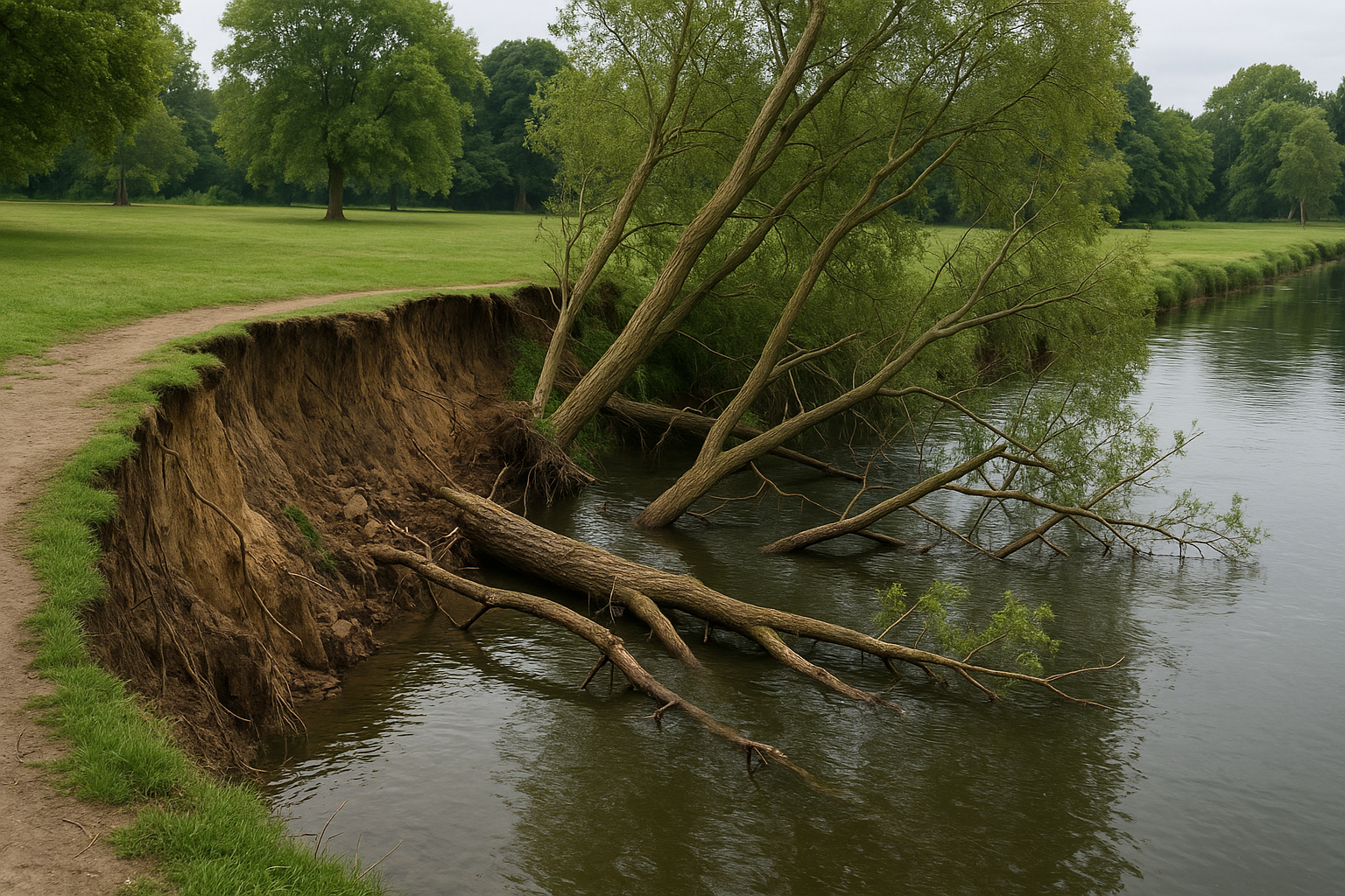
What Happened: The May 2025 Riverbank Collapse
Timeline of the Event
Based on social posts and aggregated community reports, the riverbank collapse at Iford Playing Fields occurred around May 28–29, 2025. Witnesses described hearing “a low rumble” and noticing trees leaning or falling into the water overnight.
Photos shared publicly (unverified) show:
-
Several large trees uprooted and submerged
-
A vertical bank face, estimated 2–3 meters deep
-
Nearby path edge visibly cracked and slumped
The Bournemouth Echo’s social media account summarized the incident:
“Trees collapsed into the river after the embankment gave way.” (Bournemouth Echo, X/Twitter, 2025)
While this is not an official engineering statement, it matches visual evidence and hydrological plausibility.
Weather and Soil Conditions Before the Collapse
Late spring 2025 saw unusually heavy rainfall across southern England, following a wet winter that saturated soils across the Dorset Stour catchment. The Environment Agency’s flood updates in early 2025 had already warned of unstable ground and rising water tables in parts of Bournemouth and Christchurch.
Local residents also reported strong winds in the days leading up to the incident — which could have toppled already-weakened trees whose roots were anchoring unstable soil.
Inference: Wind loading likely played a triggering role, but the underlying cause was progressive riverbank erosion and soil saturation.
Understanding the Science: Why Riverbanks Collapse
Toe Erosion: The Silent Undercutter
Most riverbank collapses start from below, not above.
Over time, flowing water at the base of the bank (the toe) erodes sediment—a process called toe scour. This removes foundational support until the upper soil mass loses balance, eventually slumping or sliding into the river.
In Iford’s case, this is especially likely given:
-
The curved channel section near Bailey Bridge Marina, which concentrates flow on the outer bend.
-
The tidal influence, which creates a repetitive wet–dry cycle, loosening cohesive soils.
Saturated Soils and Pore Pressure
When rainwater saturates soil, it fills the tiny air gaps (pores) between grains, reducing friction and shear strength.
A saturated riverbank effectively weighs more and grips less, making it far more prone to collapse—especially during or after high water events.
In spring 2025, this process was likely exacerbated by:
-
Persistent rainfall
-
Groundwater buildup
-
Tidal backwater, preventing drainage
Tree Roots: Stabilizers Turned Destabilisers
Mature trees are double-edged swords for riverbank stability:
-
Their roots bind and strengthen upper soil layers.
-
But their weight and wind-sail effect can worsen collapses once undercut.
In many collapses, roots hold firm until the very end — then fail suddenly, pulling large soil blocks into the river as they fall.
Human and Structural Factors
While natural processes dominate, human activity can accelerate erosion:
-
Mowed grass instead of deep-rooting vegetation
-
Footpath compaction near the edge
-
Drainage channels discharging directly into the riverbank
-
Vibrations from nearby transport (e.g., trains near Iford Bridge) [speculative]
These pressures slowly reduce a riverbank’s resilience.
The Aftermath: Risks and Consequences
Public Safety Concerns
The most immediate concern was public access safety. The collapsed section created a steep drop-off directly beside a popular footpath.
Without immediate cordons or barriers, risks included:
-
Falls into the river, especially at dusk or during flooding
-
Bank-edge instability, where cracks could widen unpredictably
-
Dog and child hazards, as the ground could still shift
As of June 2025, it was expected that temporary fencing or signage would be erected by BCP Council pending a full geotechnical assessment.
Environmental Impacts
Sediment and debris from the collapse likely entered the river, causing short-term increases in turbidity (cloudiness) that can affect:
-
Fish spawning beds
-
Aquatic plants
-
Invertebrate habitats
However, such impacts are typically localized and temporary.
Fallen trees can even enhance habitat diversity, acting as Large Woody Debris (LWD) that slows flow and provides refuge for fish — if properly managed and anchored.
Infrastructure and Flood Risk
While there is no verified evidence of damage to nearby infrastructure (e.g., Iford rail bridge), collapses close to assets always warrant inspection.
The bigger picture is that bank erosion reduces flood storage capacity, changes flow paths, and can influence future floodplain behavior — making proactive management essential.
Expert Analysis: Likely Causes Combined
Drawing from hydrological reasoning and EA regional data, the Iford collapse was almost certainly multi-causal:
| Contributing Factor | Mechanism | Certainty Level |
|---|---|---|
| Toe erosion | Undercutting by river flow | High |
| Saturated soils | Reduced shear strength | High |
| Vegetation weight | Trees adding load; root pull | Medium |
| Strong winds | Toppled trees triggered collapse | Medium |
| Human activity | Path compaction and runoff | Moderate |
| Subsurface layers | Weak clays or silts | [Unverified—requires testing] |
What Happens Next: Council and EA Response
Standard Post-Collapse Procedure
When a public riverbank fails, authorities typically take five immediate steps:
-
Cordon the area and close nearby paths for public safety.
-
Commission surveys, including topographical (drone-based) and geotechnical sampling.
-
Conduct a hydraulic assessment to measure scour depth and future erosion risk.
-
Design stabilization works — nature-based first, then engineered solutions if needed.
-
Engage the public, explaining safety, access changes, and restoration plans.
Governance and Funding Context
BCP Council and the Environment Agency share overlapping responsibility for Flood and Coastal Erosion Risk Management (FCERM).
The BCP FCERM Update (2024) explicitly mentions ongoing projects to strengthen riverbanks and paths across the Stour corridor. In fact, a strategic CIL prioritisation document already lists an “Iford Lane riverbank path restoration” project — showing that this stretch was on the radar even before the 2025 collapse.
Funding sources may include:
-
Community Infrastructure Levy (CIL)
-
EA Partnership Funding
-
Local flood resilience budgets
-
Public–private partnerships for amenity and access improvements
Immediate Mitigation Works
In the short term (Summer 2025):
-
The collapsed edge should be fenced and signposted.
-
Tree removal or stabilization may occur if trunks obstruct flow.
-
Surface drainage from the path should be redirected away from the scarp.
-
Visual monitoring for further slumping should continue after heavy rain.
Longer-term engineering design will depend on survey data, risk mapping, and budget availability.
Restoring the Bank: Engineering and Nature-Based Options
Soft (Nature-Based) Engineering
The preferred modern approach is nature-based stabilization, which aligns with the EA’s “Working with Natural Processes” strategy.
Options include:
-
Regrading the failed slope to a gentle 1:3 gradient
-
Installing live willow spiling (woven willow branches that root and bind soil)
-
Placing coir rolls along the toe for immediate erosion resistance
-
Planting native marginal species (sedge, reed sweet-grass, purple loosestrife)
-
Using biodegradable mats to prevent surface erosion during establishment
These methods are:
✅ Eco-friendly
✅ Visually attractive
✅ Supportive of wildlife corridors
…but they require space, time, and low flow windows to take hold.
Hard (Structural) Engineering
Where hydraulic energy is high — such as near bridge constrictions — engineered toe protection becomes necessary.
Techniques may include:
-
Rock armour (riprap): Large stones placed at the base to prevent further scour.
-
Gabions: Wire cages filled with rock, forming a flexible retaining wall.
-
Sheet piling: Steel or composite barriers driven into the bank (used sparingly).
-
Anchored log revetments: Sustainable hybrid systems using natural logs and engineered fastenings.
Engineered solutions provide immediate safety and high structural reliability, but must be blended with planting to maintain ecological and visual quality.
Path Set-Back and Access Management
In many urban rivers, the safest and most sustainable fix is to relocate the footpath slightly inland, creating a green buffer zone.
This reduces loading near the edge and gives the river room to evolve naturally without repeated repairs.
Complementary measures include:
-
Drainage ditches or swales to divert runoff
-
Interpretive signage explaining why access has shifted
-
Boardwalk sections where wetlands are seasonally inundated
Such designs transform “disaster sites” into resilient nature corridors.
Wider Environmental and Climate Context
The Iford collapse is not an isolated event. Across southern England, riverbank failures are becoming more frequent due to:
-
Increased rainfall intensity
-
Sea-level rise affecting tidal rivers like the Stour
-
Urban hardscaping, which accelerates runoff and erosion
-
Aging flood defences under more stress than they were designed for
The Environment Agency’s CFMP predicts that flood and erosion risks will increase significantly across the Dorset Stour corridor by 2050 if adaptation measures aren’t scaled up.
Community Role and Citizen Reporting
Local residents play a crucial role in early detection and risk mitigation.
How to help:
-
Report new cracks, slumps, or leaning trees to BCP Council immediately.
-
Avoid walking too close to river edges, especially after storms.
-
Keep dogs on leads near unstable ground.
-
Participate in community planting schemes if restoration begins.
-
Follow official signage and social media updates from BCP Council or the EA.
Active citizen awareness can prevent accidents — and inform better local policy.
Lessons from Iford for Urban River Management
Prevention Beats Repair
Every £1 spent on erosion prevention saves an estimated £8–10 in reactive repair costs (Environment Agency, 2023).
Routine inspections, vegetation management, and stormwater control can delay or prevent major failures.
Hybrid Design is the Future
Purely hard defences can shift erosion downstream; purely soft defences may fail under stress.
The Iford case illustrates why the best solutions combine engineering and ecology — blending strength with adaptability.
Communication Builds Trust
Residents deserve clear, transparent updates — not technical jargon.
When councils explain why paths are closed or why vegetation is left to grow, public cooperation improves and vandalism drops.
Step-by-Step Recovery Roadmap for Iford Playing Fields
| Phase | Objective | Key Actions | Timeframe |
|---|---|---|---|
| 1. Emergency Response | Ensure safety | Cordon, signage, tree checks | Immediate |
| 2. Site Investigation | Diagnose cause | Topo survey, soil tests, hydraulic modelling | 1–3 months |
| 3. Design & Consultation | Develop solutions | Hybrid design, community input | 3–6 months |
| 4. Construction | Implement works | Regrade, plant, install defences | 6–12 months |
| 5. Monitoring | Long-term stability | Post-flood inspections, vegetation health | Ongoing |
FAQs: Iford Playing Fields Riverbank Collapse
Q1. When exactly did the collapse happen?
Unverified reports suggest between 28–29 May 2025. No official incident bulletin has been issued yet.
Q2. What caused it?
Likely a combination of toe erosion, saturated soils, and wind-toppled trees.
Q3. Is the area safe now?
Until confirmed by BCP Council, visitors should assume parts of the path remain unsafe or unstable. Obey all closures and barriers.
Q4. Who’s responsible for repairs?
BCP Council (as land manager) and the Environment Agency (for in-river works) share responsibility, under the Flood and Coastal Erosion Risk Management (FCERM) framework.
Q5. Will it happen again?
Erosion is a natural process — but proactive stabilization and path set-back can greatly reduce recurrence risk.
Environmental Silver Linings
While collapses are disruptive, they also reveal opportunities for ecological enhancement:
-
Natural re-profiling can recreate floodplain habitat.
-
Exposed soil can be seeded with wetland wildflowers.
-
Fallen trees can support fish spawning and invertebrate diversity.
If managed sensitively, Iford could emerge not just repaired — but ecologically richer than before.
Long-Term Vision: A Resilient Stour Corridor
The Iford incident highlights the need for a Stour Valley Resilience Plan — a cohesive strategy linking flood, erosion, ecology, and public access across:
-
Iford
-
Holdenhurst
-
Throop
-
Christchurch Meadows
Such a plan would integrate EA modelling, BCP green infrastructure policy, and community stewardship, ensuring the Stour remains both accessible and adaptable through the 2030s and beyond.
Read Also: Izzie Balmer Partner: The Truth Behind the Rumors
Final Thoughts: Turning Collapse into Resilience
The riverbank collapse at Iford Playing Fields serves as a vivid reminder that rivers are living systems — constantly reshaping themselves in response to flow, weather, and human use.
Instead of viewing it as a disaster, the event should spark:
-
Greater awareness of erosion processes
-
Investments in preventive maintenance
-
Public dialogue about balancing recreation with resilience
With transparent communication, sound engineering, and community support, the Iford Playing Fields collapse could become a model recovery story — where safety, sustainability, and nature work together.